
A Map of the County of Louth


Section: Maps
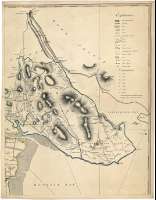
Title: A Map of the County of Louth [Mapa] / Surveyed by Taylor & Skinner, 1777 ; Engrav'd by G. Terry No 54, Parter-noster Row, Cheapside London
Author: Taylor, George
Área de datos: Escala [ca.1:41200]
Publication: London : Publish'd as the Act directs ... sold by Mrs. Dury, Dukes Courts St. Martin's Lane. - Dublin : And by W. Wilson, n° 6, Dame Street, 28th. Sepr. 1778
Physical description: 1 map. en 4 h. : col. ; 133 x 102 cm, en h. de 69 x 54 cm
Notes: Dedicatoria : "To John Foster Esquire, Knight of the Shire for the County of Louth ; This Map is with Gratitude & Respect Inscribed by this much Obliged
Escalas gráficas de 6 millas británicas de 69 1/2 al grado [= 23,4 cm] y 4millas [= 19,9 cm]. Coordenadas referidas al meridiano de Londres (O 7°40'--O 7°04'/N 54°10'--53°41'). Recuadro geográfico de 5' en 5'. Orientado con lis en rosa de dieciseis vientos prolongados
Orografía a trazos
Indica sondas batimétricas, veriles, y calidad del fondo
Destaca especialmente la división administrativa
Tabla de signos convencionales para indicar colinas, línea de costa, ríos, bosques, caminos, asentamientos de caballeros campesinos, baronías, iglesas, parroquias, castillos en ruinas
Clave de abreviaturas para los edificios más destacadas representados
Tabla que indica las distancias desde cinco lugares principales, respecto a otros puertos de menor importancia insertos en cada uno de esos cinco
Título en cartela decorada con motivos vegetales
Materia / lugar / evento: Mapas generales
Divisiones administrativas
Otros autores: Dury, Andrew, 1742-1778
Skinner, Andrew, fl. ca. 1777-1778
Wilson, William
Terry, Garnet
Títulos secundarios: LOUTH (Irlanda). Condado. Mapas generales. 1777. 1:41200
UDC: 912:(1-28)(417)"1777"
417 Louth, Condado
Type of publication:
 Maps
Maps
Derechos: