
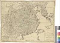
The Empire of China with its Principal Divisions


Section: Maps
Title: The Empire of China with its Principal Divisions [Mapa] / drawn from the Surveys made by the Jesuits with Improvements and Additions from the Maps of Mnsr. D'Anville ; M. Borven sculpt
Author: Borven, M.
Área de datos: Escala [ca. 1:6260000]
Publication: London : Printed for Robert Sayer, Fleet Street, 1790
Physical description: 1 map. : col. ; 47 x 62 cm
Notes: Comprende desde el golfo de Tonkin a la península de Corea, llegando en el interior hasta el límite de la Gran Muralla China
Escalas gráficas de 20 leguas de 20 al grado [= 7 cm], de 800 Furlongs chinos de 200 al grado, 800 "small Li" de 250 al grado y de 400 millas estatutarias. Coordenadas referidas al meridiano de Ferro (E 107°--E 154°/N 43°--N 18°)
Orografía de perfil
Límites provinciales diferenciados por colores
Materia / lugar / evento: Mapas generales
Divisiones administrativas
Otros autores: Sayer, Robert, 1725-1794
Títulos secundarios: CHINA. SE. Mapas generales. 1:6260000 (1790)
UDC: 912:(1-35)(510-12)"1790"
510-12
Type of publication:
 Maps
Maps
Derechos: