Plan d'Alexandrie


-
Secció: Planos
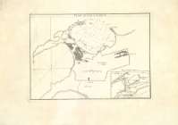
Títol: Plan d'Alexandrie [Material cartográfico] / [Par le Sr. D'Anville]
Àrea de dades: [c.a. 1:17.036]. 500 Toises, [= 5,72 cm]
Publicació: [París] : [s.n.], [17??]
Descripció física: 1 mapa ; 54 x 38 cm
Notes: Copia digital. Madrid : Ministerio de Cultura. Dirección General del Libro, Archivos y Bibliotecas, 2010
Inserta mapa: AlexandriaRegistres relacionats: En: Atlas o Cartes Geographiques. - [París : s.n., 1786?]. - Mapa 46
Registros incluidos: Atlas o Cartes Geographiques . - [París : s.n., 1786?]
Materia / lugar / evento: Geografía antigua - Mapas
Alejandría (Egipto) - Mapas Género / forma: Planos de población
Nom jeràrquic de lloc: Egipto - Alejandría
Títols secundaris: Alejandría. Cartas naúticas. ca. 1731
CDU: (621)
Tipus de publicació:
 Mapes
Mapes
Derechos:
Museu NavalSignatura: A-10151_64