
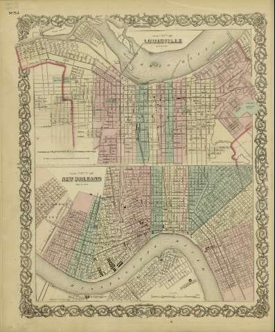
The city of New Orleans, Louisiana


Secció: Mapes
Títol: The city of New Orleans, Louisiana / [drawn by George Woolworth Colton]
Àrea de dades: Escala [ca. 1:31.928], 1 mile [= 5'8 cm]
Publicació: New York : published by G.W. and C.B. Colton & Co., [1872]
Descripció física: 1 mapa : col. ; 22 x 36 cm, en h. de 44 x 36 cm
Notes: Indica divisiones administrativas marcadas por colores.
Con: The city of Louisville, Kentucky
Inserta nota: "Entered according to Act of Congress in the year 1855 by J.H. Colton & Co. in the Clerk's office of the district court for the southern district of New York".
Registres relacionats: En: Colton's General Atlas : containing one hundred and eighty steel plate maps and plans, on one hundred and nineteen imperial folio sheets. - New York : published by G.W. and C.B. Colton & Co. n 172 William St., [1872]. - Nº 54
Materia / lugar / evento: Planos de población
Nueva Orleans - Planos
Nom jeràrquic de lloc: Estados Unidos - Nueva Orleans
Otros autores: G.W. & C.B. Colton & Co.
Títols secundaris: NUEVA ORLEANS (Estados Unidos) (Luisiana). 1:31928
CDU: 912:[711.4+625.712+625.1+556.53](763 Nueva Orleans)'1872'
763 Nueva Orleans
912:314(763 Nueva Orleans)
Tipus de publicació:
 Mapes
Mapes
Derechos: