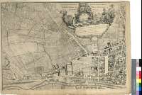
An Accurate Survey of the City and Suburbs of Dublin
Secció: Mapes
Títol: An Accurate Survey of the City and Suburbs of Dublin [Material cartográfico] / By Mr. Rocque ; With Additions, and Improvements, By Mr. Bernard Scalé to 1733
Autor: Rocque, John, fl. 1734-1762
Àrea de dades: Escala [ca. 1:2500]
Publicació: London : Printed for Robt. Sayer Map and Printseller, No. 53 in Fleet Street, Published as the Act directs, 1 January 1773
Descripció física: 1 plan. en 4 h. ; 98 x 140 cm, en h. de 53 x 74 cm
Notes: Dedicatoria : "To the Honourable the Dublin Society for the Encouragement of Arts and Manufactorys, and to the Committy of Merchants of the City of Dublin this Plan is most humbly Inscribed by their most Obedient humble Servant, Robert Sayer"
Escalas gráficas de 1000 pies británicos [= 12,2 cm], 40 irlandeses, 40 ingleses y 110 toesas
Orografía por normales
Tabla de signos convencionales para indicar los principales edificios de la ciudad
Título, autor. editor y dedicatoria en cartela rococó decorada con alegorías sobre Irlanda
Forma parte de la Colección Mendoza
Materia / lugar / evento: Dublín - S. XVIII - Mapas
Género / forma: Planos de población
Nom jeràrquic de lloc: Irlanda - Dublín
Otros autores: Scalé, Bernard, fl.1760-1787
Sayer, Robert, 1725-1794
Títols secundaris: DUBLIN (Irlanda) (Leinster). Planos de población. 1:2500 (1773)
CDU: 912:[314(084.3)](417)"1773"
417 Dublín
Tipus de publicació:
![]() Mapes
Mapes
Derechos: CC BY. Esta licencia permite utilizar las obras siempre que se mencione la fuente de procedencia
© Ministeri de Cultura


