
A Map of the County of Berks : Reduced from an Actual...


Secció: Mapes
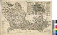
Títol: A Map of the County of Berks [Material cartográfico] : Reduced from an Actual Survey in 18 Sheets = Carte de la Province de Berks : Rediut D'apres un arpantage en 18 Fevilles / By the Late John Rocque Topographer to his Majesty 1762 = Par Jean Rocque Topographe de Sa Majeste Britanique 1764
Autor: Rocque, John, fl. 1734-1762
Àrea de dades: Escala [ca. 1:128000]
Publicació: [London] : Published according to Act of Parliament, by Mary Ann Rocque hear old Round Court in the Strand, 1762
Descripció física: 1 map. : col ; 43 x 66 cm
Notes: Escalas gráficas de 5 millas estatutarias [= 6,3 cm], 2000 "Perches", 12000 yardas y 3 leguas de 25 en grado. Coordenadas referidas al meridiano de San Pablo (O 1°35--O 0°23'/N 51°49'--N 51°20'). Recuadro geográfico de 4' en 4'
Orograía por normales
Divisionmes administrativas diferenciadas mediante colores
Tabla de signos convencionales para indicar la categoría de los núcleos de población, carreteras, etc.
Títulos y autor en cartela decorada con escena campestre
Forma parte de la Colección Mendoza
Inserta : "A Plan of the City of Oxford". Escala [ca. 1:10000], 500 yardas [= 4,4 cm] y 20 "chains" [= 4 cm]. Orientado con lis en rosa de ocho vientos. Relación de los principales edificios, calles y colegios universitarios indicados por clave alfanumérica. Nota con breve descripción de la ciudad
Fecha más reciente reflejada en el mapa 1764
Materia / lugar / evento: Berkshire - S. XVIII - Mapas
Oxfordshire - S. XVIII - Mapas
Inglaterra - Divisiones territoriales - S. XVIII - Mapas
Género / forma: Mapas administrativos
Nom jeràrquic de lloc: Gran Bretaña
Otros autores: Rocque, Mary Ann, S. XVIII
Títols secundaris: BERKSHIRE (Reino Unido) (Inglaterra). Mapas generales. 1:128000 (1762)
CDU: 912:[314(084.3)]:(1-37)(420)"1762"
420 Berkshire, Condado
420 Oxford
Tipus de publicació:
 Mapes
Mapes
Derechos: