
[The County of Cheshire]


Secció: Mapes
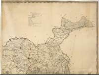
Títol: [The County of Cheshire] [Material cartográfico] / The Roads Meres & Commons of this Map were Engraved by P.P. Burdett and the rest by T. Billinge of Liverpool
Edició: 2nd. Edition
Àrea de dades: Escala [ca. 1:65000]
Publicació: London : Published boy W. Faden, Geogr. to His Majesty, and to H.R.H. the Prince of Wales, Charing Cross, June 1 st. 1794
Descripció física: 1 map. en 4 h. : col. ; 112 x 148 cm, en h. de 60 x 77 cm
Notes: Dedicatoria : "By Permission to His Royal Highness, George, Prince of Wales, Duke of Cornwall & Roshsay, and Earl of Chester &c. &c. This Survey of the County Palatine of Chester, is most humbly Dedicated, by His Royal Highnefs's most Devoted Servant P.P. Burdett"
Título redactado a partir del contenido del documento
Escala gráfica de 6 millas [= 14,9 cm]. Coordenadas referidas al meridiano de Londres (O 3°23'30''--O 1°44'20''/N 53°39'20''--N 52°59'55''). Recuadro geográfico de 5' en 5'. Orientado con lis en rosa de ocho vientos
Orografía a trazos
Tabla de signos convencionales para indicar ciudades, parroquias, molinos, límites entre "hundreds", etc.
Dedicatoria enmarcada en cartela decorada con motivos vegetales
Forma parte de la Colección Mendoza
Inserta : "The Series of great triangles reduce to an Horizontal Plane" ; "A Plan of the City of Chester". Escala [ca. 1:6800], 600 yardas [= 8,1 cm]
Materia / lugar / evento: Cheshire - S. XVIII - Mapas
Inglaterra - Divisiones territoriales - S. XVIII - Mapas
Género / forma: Mapas administrativos
Nom jeràrquic de lloc: Gran Bretaña - Inglaterra
Otros autores: Faden, William, 1750-1836
Billinge, Thomas, 1741-1816
Burdett, Peter P., fl. 1786-1794
Títols secundaris: CHESHIRE (Reino Unido) (Inglaterra). Mapas generales. 1:65000 (1794)
CDU: 912:[528.02/.03]+314(084.3)](420-37)"1794"
420 Cheshire, Condado
420 Chester
Tipus de publicació:
 Mapes
Mapes
Derechos: