
A Topographical Map of the county of Sussex : Divided...


Secció: Mapes
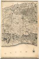
Títol: A Topographical Map of the county of Sussex [Material cartográfico] : Divided into Rapes, Deanvies and Hundreds, Pland from an actual Survey by a Scale of one Inch to a Statute Mile / begun by W. Garddner and the late T. Yaekell ; Completed by Thos. Gream, Land Surveyor, Villers Street, Strand ; Engraved by Thos. Foot, Weston Place, Battle Bridge
Autor: Gardner, William
Àrea de dades: Escala [63360] (O 0°58'--E 0°48'/N 51°08'--N 50°43')
Publicació: London : Published by W. Faden, Geographer to His Majesty and to His R.H. the Prince of Wales. Charing Cross, June 4 th. 1795
Descripció física: 1 map. en 4 h. : col. ; 74 x 195 cm, en h. de 80 x 52 cm
Notes: Comprende los actuales condados ingleses de Sussex del Oeste y Sussex del Este
Dedicatoria : "To His Grace Charles Lenox, Duke of Richmond, Lenox and Aubigny, Earl of March, Lord Lieutenant and Custos Rotulorum of the County of Sussex &c. &c. &c. This Map is with Permission dedicated by the Proprietor William Faden. Charing Cross, June 4 th. 1795"
Escala también dada de forma gráfica, en 4 millas estatutarias. Recuadro de 5' en 5'. Orientado en rosa de ocho vientos
Orografía a trazos. Bajos y bancos de arena
Límites jurisdicciones diferenciados mediante colores
Forma parte de la Colección Mendoza
Materia / lugar / evento: Inglaterra - Divisiones territoriales - S. XVIII - Mapas
Sussex del Este - S. XVIII - Mapas
Género / forma: Mapas topográficos
Nom jeràrquic de lloc: Gran Bretaña - Inglaterra
Otros autores: Yeakill, Thomas
Gream, Thomas
Faden, William, 1750-1836
Foot, Thomas, fl. 1790-1827
Títols secundaris: SUSSEX DEL OESTE (Reino Unido). Inglaterra. Condado. Mapas generales. 1795. 1:63360
CDU: 912(420-28)"1795"
420 Sussex del Oeste, condado
420 Sussex del Este, condado
Tipus de publicació:
 Mapes
Mapes
Derechos: