
Plan of the City & Suburbs of Exeter


Secció: Planos
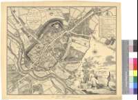
Títol: Plan of the City & Suburbs of Exeter [Mapa] / Surveyed by C. Trozer ; engraved by Thos. Yeakell
Àrea de dades: Escala [ca. 1:2300]
Publicació: [United Kingdom] : Publis'd by C. Tozer, April 20 th. 1792
Descripció física: 1 plan. ; 37 x 45 cm
Notes: Dedicatoria : "To the Right Woshipful the Mayor, Recorder, Sheriff, Aldermen, & Commonalty of the City of Exeter this Plans is humbly Dedicated by their most obedient humble Servt. Chas. Tozer"
Escala gráfica de 80 poles, cada uno de 16 1/2 pies o un estadio [= 8,3 cm]. Orientado con lis en rosa de dieciseis vientos
Toponimia de calles y plazas
Relación de los edificios civiles y religiosos señalando los distritos en que se encuentran, indicados por clave alfabética
Título enmarcado en paisaje rural donde una figura femenina alegórica sostiene el escudo de la ciudad y a cuyos pies se encuentran libros con la historia del condado. Relación de edificios en cartela decorada con el escudo del obispado. Dedicatoria en cartela ovalada
Forma parte de la Colección Mendoza
Materia / lugar / evento: Planos de población
Devon
Inglaterra (Reino Unido)
Otros autores: Yeakill, Thomas
Títols secundaris: EXETER (Reino Unido) (Inglaterra). Planos de población. 1:2300 (1792)
CDU: 912:[314(084.3)](420)"1792"
420 Exeter
Tipus de publicació:
 Mapes
Mapes
Derechos: