
A Map of the Town of Penrith and the Country Adjacent


Secció: Mapes
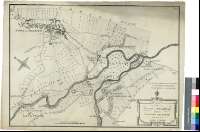
Títol: A Map of the Town of Penrith and the Country Adjacent [Mapa] / Surveyed by James Clarke ; S.J. Neele, sulpt. 352 Strand, London
Autor: Clark, James, m. 1790
Àrea de dades: Escala [ca. 1:6400]
Publicació: [Penrith : James Clark, 1787?]
Descripció física: 1 map. ; 47 x 65 cm
Notes: Pie de imprenta tomado de otros documentos del autor
Escala gráfica de 35 "Chains" [= 11 cm]. Orientado con lis en rosa de cuatro vientos
Destaca los caminos y núcleos de población más importantes
En el ángulo superior derecho : "Plate 1"
Título y autor en cartela decorada con guirnaldas
Forma parte de la colección Mendoza
Materia / lugar / evento: Mapas generales
Planos de población
Cumbria
Inglaterra
Otros autores: Neele, Samuel John, 1758-1824
Títols secundaris: PENRITH (Reino Unido). Inglaterra. Ciudad. Mapas generales. 1787?. 1:6400
CDU: 912:314(084.3)(420)"1787"
420 Cumbría
Tipus de publicació:
 Mapes
Mapes
Derechos: