
A Map of the Country ten miles round Newbury in Berkshire...


Secció: Mapes
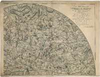
Títol: A Map of the Country ten miles round Newbury in Berkshire : with a plan of the Town of Newbury and of Speenhamland [Mapa] / John Willis
Autor: Willis, John
Àrea de dades: Escala indeterminada
Publicació: [S.l. : s.n., 1768?]
Descripció física: 1 map. en 4 h. : col. ; 101 cm diam., h. de 52 x 73 cm
Notes: Dedicatoria : "To the Right Honorable William Lord Graven the High Stewardthe Worshipful the Mayor Robert van Sittart Esqr. the Recorder, the Alderman And Capital Burgesses of the Borough of Newbury this Map is dedicated by their most humble Servant John Willis
Fecha de publicación tomada del "Tooley's dictionary of Mapmakers", Tring, 1979, p.668
Orografía a trazos
Límites parroquiales diferenciados por colores
En el margen izquierdo amplia leyenda sobre la ciudad de Newbury
Inserta : "A plan of the Town of Newbury and Speenhamland". Escala [ca. 1:3200], 2 fulongs [= 12 cm]. Orientado con lis en rosa de ocho vientos. Relación de los principales edificios de la ciudad indicados por clave alfabética
Materia / lugar / evento: Planos de población
Inglaterra (Reino Unido)
Newbury (Reino Unido) (Inglaterra) (Ciudad)
Títols secundaris: BERKSHIRE (Reino Unido) (Inglaterra). SO. Mapas generales (1768?)
CDU: 912]:[314(084.3)](420)"1768"
420-14, Berkshire, condado
420, Newbury, ciudad
Tipus de publicació:
 Mapes
Mapes
Derechos: