
A Map of Warwickhire


Secció: Mapes
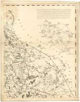
Títol: A Map of Warwickhire [Mapa] / Drawn from an Actual Survey taken in the years 1787-1788-1789 by Willm. Yates & Son for John Sharp
Autor: William Yates and Sons
Àrea de dades: Escala [ca.1:65000]
Descripció física: 1 map. en 4 h. : col. ; 133 x 103 cm, en h. de 70 x 55 cm
Notes: Escalas gráficas de 6 millas estatutarias de 69 1/2 al grado [= 14,8 cm] y 6 millas geográficas de 60 al grado [= 17,2 cm]. Coordenadas referidas al meridiano de Londres ( O 1°59'0''--O 1°03'30''/N 52°42'00''--N 51°57'00'') Se traza además el meridiano que pasa por Warwick. Recuadro geográfico de 5' en 5'. Orientado con lis en rosa de ocho vientos prolongados
Orografía a trazos
Destaca especialmente la división administrativa
Tabla de signos convencionales para indicar lugares importanrtes de feria de mercado, casas de caballeros campesinos y granjas, iglesias, capillas y demás edificios religiosos y caminos
Leyenda explicativa sobre un diagrama que hay inserto en el documento, para calcular las distancias entre los diversos puntos del condado
Decorado con el grabado del catillo de Warwick y St Mary's Tower
Inserta un diagrama en el que aparecen reflejados algunas de las triangulaciones geodésicas realizadas en la elaboración de este mapa
Materia / lugar / evento: Triangulaciones
Mapas generales
Divisiones administrativas
S.XVIII
Inglaterra
Otros autores: William Yates and Sons
Sharp, John, fl. ca. 1793
Títols secundaris: WARWICKSHIRE (Reino Unido) (Inglaterra). Mapas generales. 1793. 1:65000 (1787-1789)
CDU: 912:(1-28)+528.02/03](420)"1787-1789"
420 Warwickshire, condado
Tipus de publicació:
 Mapes
Mapes
Derechos: