
Cary's New and Accurate Map of the County of Surry :...


Secció: Mapes
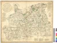
Títol: Cary's New and Accurate Map of the County of Surry : Divided into its Hundreds with the Roads, Rivers, Parks, Antiquities &c. : From an Actual Survey : and the Parishes arranged under their respective Hundreds : the Borough and Market Town expressed and the Days presixed on which they are held, with the distances from the Metropolis [Mapa]
Àrea de dades: Escala [ca. 1:89400]
Publicació: London : Publish'd by John Cary, Engraver, Map & Print-seller, N° 188, corner of Arundel Street, Strand, March 26, 1785
Descripció física: 1 map. : col. ; 60 x 75 cm
Notes: Escala gráfica de 6 millas estatutarias [= 10'8 cm]. coordenadas referidas al meridiano de San Pablo (O 0°46'--O 0°10'/N 51°32'--N 51°04'). Recuadro geográfico de 5' en 5'. Orientado con lis
Orografía por normales
Tablas y clave cromática para indicar las divisiones administrativas del condado de Surrey
Nota indicando los dias de mercado en los núcleos de población más importantes
Tabla de signos convencionales para indicar los rios, casas, etc.
Materia / lugar / evento: Mapas generales
Divisiones administrativas
Inglaterra
Otros autores: Cary, John, ca. 1754-1835
Títols secundaris: SURREY (Reino Unido). Inglaterra. Condado. Mapas generales. 1785. 1:89400
CDU: 912:339.3+(1-37)(420)"1785"
420 Surrey, condado
Tipus de publicació:
 Mapes
Mapes
Derechos: