
Bowles's New Pocket Map of the Coast of Africa : from Sta...


Secció: Mapes
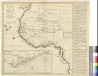
Títol: Bowles's New Pocket Map of the Coast of Africa [Material cartográfico] : from Sta. Cruz, Lat. 30 N. to Angola, Lat. 11 S. With Explanatory Notes ; and a correct chart of the Cold Coast
Autor: Bowles, Carrington
Àrea de dades: [Ca. 1:10800000]
Publicació: London : Printed for the Proprietor Carington Bowles, N°69 in St. Pauls Church Yard, [17--?]
Descripció física: 1 mapa : col. ; 47 x 47 cm, en h. de 51 x 59 cm
Notes: Escalas gráficas de 80 leguas portuguesas [= 4,6 cm], 80 millas holandesas [= 4,5 cm] y 100 leguas inglesas de 23 1/9 al grado [= 4,9 cm]. Coordenadas referidas al meridiano de Londres (O 28°30'-E 18°50'/N 31°00'-S 111°30'). Red geográfica de 5° en 5°. Orientado con lis en rosa de dieciséis vientos
Relieve de perfil
Señala mediante colores las fronteras entre los distintos reinados y territorios
Indica la dirección de las corrientes marinas
Figura amplia leyenda sobre las características generales de la costa y breves notas históricas, distribuidas por todo el documento
Inserta: A correct chart of the Gold Coast : According to the Sr. Danville on a Larger Scale. Escala [ca. 1:1500000], 20 leguas marinas inglesas y francesas de veinte al grado [= 7,3 cm]. Nudo de rumbos e indicación de los límites entre los reinos
Materia / lugar / evento: África occidental - Costas - S. XVIII - Mapas
Género / forma: Mapas administrativos
Nom jeràrquic de lloc: África occidental
Otros autores: Anville, Jean-Baptiste Bourguignon d', 1697-1782
Títols secundaris: AFRICA. NO. Mapas generales. 1:10800000 (17)
CDU: 912:(1-4)(6-16)"17"
6-16
Tipus de publicació:
 Mapes
Mapes
Derechos: