
A new map of the Kingdom of Poland, with its Dismembered...


Secció: Mapes
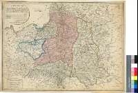
Títol: A new map of the Kingdom of Poland, with its Dismembered Provinces and the Kingdom of Prussia [Mapa]
Àrea de dades: Escala [ca. 1:2440000]
Publicació: London : Published... by Laurie & Whittle, No. 53 Fleet Street, 12th. May, 1794
Descripció física: 1 map. : col. ; 48 x 65 cm
Notes: Comprende Polonia, la provincia de Kaliningrandskaia Oblast', Lituania, Letonia, Bielorrusia, Ucrania y parte de la URSS hasta Kaluga
Escalas graficas de 25 leguas polacas y alemanas de 15 al grado [= 7,6 cm]30 leguas geométricas de 20 al grado, 120 millas inglesas de 69 1/2 al grado y 40 leguas francesas de 25 al grado. Coordenadas referidas al meridiano de Londres (E 13°14'--E 34°36'/N 57°22'--N 47°18')
Orografía de perfil
Territorios y límites diferenciados por color
Consta una estadística demográfica de las repúblicas y provincias representadas
Forma parte de la Colección Mendoza
Materia / lugar / evento: Mapas generales
Divisiones administrativas
Kaliningrandskaya Oblast' (URSS) (RSFS de Rusia) (Provincia)
Moldavia
Bielorrusia
Ucrania
RSFS de Rusia (URSS)
Otros autores: Laurie and Whittle (Londres)
Títols secundaris: POLONIA. Mapas generales. 1794. 1:2440000
CDU: 912:(1-2/-5)(477-15)(474.5)(476)(470.1)(438)"1794"
476
477-15
474-15
470.1 Kaliningradskaya Oblast'
438
Tipus de publicació:
 Mapes
Mapes
Derechos: