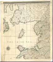
England and Ireland containing all the Cities, Boroughs,...
Secció: Mapes
Títol: England and Ireland containing all the Cities, Boroughs, Market-Tows & principal Villages, with the Coast of France from Calais to Brest / Delineated and Engraved from Actual Surveys By Richard William Seale Geographer
Autor: Seale, Richard William, m. 1785
Àrea de dades: Escala [ca. 1:590000]
Publicació: London : Printed for Robert Wilkinson 58 Cornhill : Laurie & Whittle, 53 Fleet Street : and, Bowles & Carver, 69 St. Paul's Church-Yard, [1794-1795]
Descripció física: 1 mapa en 8 h. : col. ; 151 x 156 cm en h. de 63 x 55 cm o menos
Notes: Se ha tomado esta fecha de publicación por ser la única a la que los editores pudieron trabajar juntos, teniendo en cuenta las sedes de sus talleres
Escalas gráficas de 25 millas geométricas de 60 al grado [= 7,9 cm], 8 leguas inglesas y francesas de 3 millas geométricas, 30 millas estatutarias inglesas, 20 millas irlandesas, 20 millas de 48 al grado y 10 leguas comunes francesas de 25 al grado. Coordenadas referidas al meridiano de Londres (O 10°00'00''-E 2°00'00''/N 55°40'05''-N 49°38'00''). Red geográfica de 20' en 20'. Orientado con lis en rosa de treinta y dos vientos
Relieve de perfil
Señala con colores las divisiones administrativas
Tabla de signos convencionales para indicar distintos tipos de población, fortificaciones, lugares donde tuvieron lugar batallas, y carreteras en las que se señalan las distancias, en millas entre distintos puntos
Título, autor y editores enmarcado en cartela barroca con escena bélica y escudo de la casa real inglesa y las escalas con otra decorada con motivos vegetales y geográficos
Forma parte de la Colección Mendoza
Inserta: "A Map of Scotland, containing all ye Cities, Market and Borough Towns, with ye principal Roads and Distances in Computed Miles". Escala [ca. 1:2670000], 30 millas escocesas [= 2,5 cm] ; Mapa de las islas Setland y Orkney ; "2d. Chart of the Coast of France, from Ostende, Ambleteuse"
Materia / lugar / evento: Mapas generales
Fortificaciones
Carreteras
Divisiones administrativas
Núcleos de población
Irlanda
Otros autores: Seale, Richard William, m. 1785
Wilkinson, Robert, fl. 1785-1825
Bowles and Carver
Laurie and Whittle (Londres)
Títols secundaris: REINO UNIDO. Mapas generales. 1:590000 (1795)
CDU: 912:314:625.7:623.1(41)"1794/1795"
41
Tipus de publicació:
![]() Mapes
Mapes
Derechos: CC BY. Esta licencia permite utilizar las obras siempre que se mencione la fuente de procedencia
© Ministeri de Cultura


