
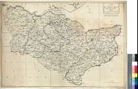
A Map of the County of Kent : Taken from an Actual Survey...


Secció: Mapes
Títol: A Map of the County of Kent : Taken from an Actual Survey as an index to the large one [Mapa] / T. Kitchin Sculp
Autor: Kitchin, Thomas, 1718-1784
Área de datos: Escala [ca. 1:154000]
Publicació: [London : s.n., 17--?]
Descripció física: 1 map. : col.49 x 70 cm ; ii
Notes: Escala gráfica de 9 millas [= 9,4 cm], Orientado con lis en cuadrante
Orografía de perfil
Divisiones administrativas del condado diferenciadas por color
Materia / lugar / evento: Mapas generales
Divisiones administrativas
S.XVIII
Inglaterra
Títulos secundarios: KENT (Reino Unido) (Inglaterra) (Condado). Mapas generales. 1:152400 (17)
CDU: 912:(1-37)(420)"17"
420 Kent, condado
Tipus de publicació:
 Mapes
Mapes
Derechos:
Museu Naval
Signatura: MN 127-3