
England and Wales : Drawn from the most accurate Surveys...


Sección: Mapas
Título: England and Wales [Material cartográfico] : Drawn from the most accurate Surveys Containing all the Cities, Boroughs, Market Towns & Villages : In Which are inuded all the Improvements and observations both Astronomical and Topographical which have been made by Members of the Royal Society & other down to the present year / By John Rocque Chorographer to his Majesty
Autor: Rocque, John, fl. 1734-1762
Área de datos: Escala [ca. 1:690000]
Publicación: [London] : Published by Laurie & Whittle, N° 53, Fleet Street, as the Act directs, 12 th May, 1794
Publicación, Producción, Distribución, etc.: Fabricación: [London] : Printed for Robt. Sayer Map & Printseller at the Golden Buck in Fleet Street, 12 th May, 1794
Descrición física: 1 map. en 4 h. : col. ; 11,6 x 100 cm. en h. de 62 x 53 cm
Apuntamentos: Escalas gráficas de 60 millas estatutarias [= 14 cm] y 20 leguas marinas británicas [= 16,3 cm]. Coordenadas referidas al meridiano de Londres (O 7°08'--E 3°19'/N 56°19'--N 49°25'). Red geográfica de 1° en 1°. Orientado con lis en rosa de dieciseis vientos
Orografía de perfil
Indica veriles y bancos de arena
Divisiones administrativas diferenciadas por colores
Distancias entre ciudades señaladas en el mapa y explicadas en nota
Tabla de signos convencionales para indicar la categoría de las ciudades y caminos
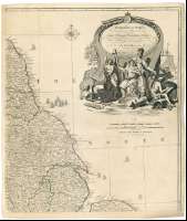
Título y autor en cartela rococó decorada con alegorias sobre el mar. Mar surcado por barcos
Forma parte de la colección Mendoza
Inserta : "Isles of Scilly : These Isles are Drawn to the same Scale...". Coordendas referidas al meridiano de Londres (O 7°24'--O 6°10'/N 50°07'--N 49°50')
Materia / lugar / evento: Inglaterra - Divisiones territoriales - S. XVIII - Mapas
Gales - Divisiones administrativas - 1648 - Atlas
Género / forma: Mapas administrativos
Nome xerárquico de lugar: Gran Bretaña - Inglaterra
Gran Bretaña - Gales
Títulos secundarios: INGLATERRA (Reino Unido). Mapas generales. 1:690000 (1794)
CDU: 912:(1-35)(420)(429)"1794"
420
429
Tipo de publicación:
 Mapas
Mapas
Derechos: