
A Plan of the Proposed Union Canal, to join the Leicester...


Sección: Planos
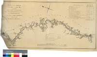
Título: A Plan of the Proposed Union Canal, to join the Leicester Navigation with a Branch of the Grand Junction Canal, near Northampton [Material cartográfico]: also of a Branch to Market Harborough / Surveyed in 1792, by John Varley Senr. & Christr. Staveley Junr
Autor: Varley, John , Senior
Área de datos: Escala [ca. 1:64400]
Publicación: [London] : Engraved by W. Faden, Geogr. to the King & His R.H. the Prince of Wales, Charing Cross, 1792?
Descrición física: 1 map. ; 39 x 78 cm
Apuntamentos: Comprende parte de los condados ingleses de Leicestershire y Northamptonshire
Escalas gráficas de 9 millas y 72 estadios [= 22,5 cm]
Orografía a trazos
Tabla de signos convencionales para indicar el trazado del canal proyectado, distintos tipos de caminos y molinos de agua
Consta una tabla con datos referentes a las dimensiones y capacidad de los tramos de la obra proyectada
Forma parte de la Colección Mendoza
Materia / lugar / evento: Inglaterra - S. XVIII - Mapas
Inglaterra - Canales - Mapas
Leicestershire - Canales - S. XVIII - Mapas
Northamptonshire - Canales - S. XVIII - Mapas
Nome xerárquico de lugar: Gran Bretaña - Inglaterra
Otros autores: Staveley, Christopher , Junior
Faden, William, 1750-1836
Títulos secundarios: UNION (Reino Unido). Inglaterra. Canal. Canales. 1792?. 1:64400
CDU: 912:626.13(083.9)]+625.7(420)"1792"
420 Unión, canal
420 Leicestershire, condado
420 Northamptonshire, condado
Tipo de publicación:
 Mapas
Mapas
Derechos: