
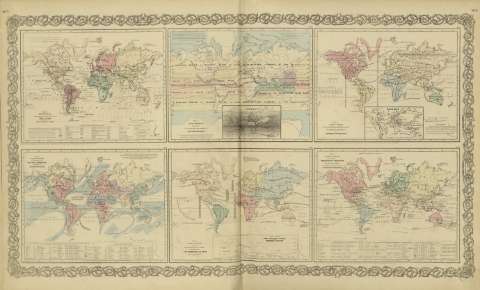
Map of the world illustrating the productive industry of...


Sail: Mapak
Izenburua: Map of the world illustrating the productive industry of various countries & exhibiting the principal features of commerce and navigation / [drawn by George Woolworth Colton]
Autorea: Colton, George Woolworth, 1827-1901
Datu-area: Escala indeterminada (O 180º--E 180º /N 80º-- S 70º)
Argitalpena: New York : published by G.W. and C.B. Colton & Co., [1872]
Deskribapen fisikoa: 1 mapa : col. ; 17 x 22 cm, en h. de 44 x 36 cm
Oharrak: Inserta : Statistical table of the principal countries.
Con : Map of the world illustrating the principal features of the land and the co - tidal lines ; Map of the world showing the principal ocean currents & boundaries of river systems ; Map of the world illustrating the principal features of meteorology ; Map of the world showing the distribution and limits of cultivation of the principal plants ; Map of the world showing the geographical distribution & range of the principal members of the animal kingdom.
Erregistro erlazionatuak: En: Colton's General Atlas : containing one hundred and eighty steel plate maps and plans, on one hundred and nineteen imperial folio sheets. - New York : published by G.W. and C.B. Colton & Co. n 172 William St., [1872]. - Nº 7- 8
Materia / lugar / evento: Geografía comercial
Producción industrial
Rutas de comercio
Estadísticas
Mundo - Mapas
Otros autores: G.W. & C.B. Colton & Co.
Bigarren mailako izenburuak: Mundo. Geografía comercial (1872)
CDU: 912:339.1]:[338.45+656.02:339.1+311.2](100)'1872'
100
Argitalpen mota:
 Mapak
Mapak
Derechos: