
To the Right Honorable the Master Wardens & Elder...


Section: Maps
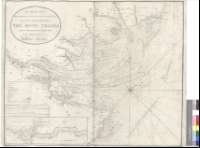
Title: To the Right Honorable the Master Wardens & Elder Brethren of the Trinity House, this Chart of the entrances to the River Thames, is most respectfully dedicated by their obliged humbre Servant William Heather [Mapa] / Engraved by J. Stephenson
Author: Heather, William, 1764-1812
Área de datos: Escala [ca. 1:200000]
Publication: London : Published as the Act directs... W. Heather, at the Navigation Warehouse, No. 15 Leadenhal Street, November [1795-1802?]
Physical description: 1 map. ; 63 x 78 cm
Notes: Comprende desde la desembocadura del río hasta Parsleet
Fecha de edición calculada teniendo en cuenta el intervalo en que se han publicado los mapas que le acompañan
Escalas gráficas de 20 millas inglesas y francess de 60 al grado y 5 millas danesas y alemanas de 15 al grado [= 18,7 cm]. Orientado con lis en rosa de treinta y dos vientos
Orografía de perfil
Indica sondas batimétricas, veriles, bajos, bancos, fondeaderos, la dirección de las corrientes, y boyas y faros ; estos últimos, destacados en rojo con posterioridad a la publicación del documento
Tabla de signos convencionales para indicar el contenido náutico de la carta y los principales núcleos de población
Inserta : "A Continuation of the River Thames from Erith to London". Escala [ca. 1:81000], 3 millas inglesas [= 6'9 cm]
Está incluído en un grupo de mapas dispuestos a modo de cuaderno : "North Sea" ; "East coast of England" ; "East coast of England and Scotland" ; A New Chart of Holland with the entrances to the Scheld" ; "The Coasts of Holland and England" ; "A New and Improved Chart of the Rivers Elbe and Weser to Hamburg and Bremen"
Forma parte de la colección Mendoza
Otros autores: Heather, William, 1764-1812
Stephenson, J., fl. ca. 1795-ca. 1802
Títulos secundarios: TAMESIS (Río). Cartas náuticas. 1:200000 (1795-1802?)
UDC: 912:551.46]+[801.311](282.242)"1795/1802"
282.242
Type of publication:
 Maps
Maps
Derechos: