
A New and Accurate Map of the County of Cornwall : from...


Section: Maps
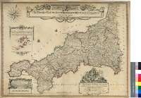
Title: A New and Accurate Map of the County of Cornwall [Material cartográfico] : from an Actual Survey / Made by Thos. Martyn
Author: Martyn, Thomas, 1735-1825
Área de datos: Escala [ca. 1:173000]
Publication: London : Printed for Willam, Geographer to the King, Charing Cross, Feby. 20 th. 1784
Physical description: 1 map. : col. ; 54 x 72 cm
Notes: Dedicatoria : "To Jonathan Rashleigh of Menabilly Esq. Member of Parliament for the Borough of Fowey, In the County of Cornwall, This Map is most humbly Inscrib'd, By His most humble and Obedient Servant, Thos. Martyn"
Escala gráfica de 10 millas [= 9,3 cm]. Coordenadas referidas al meridiano de Londres (O 6°05'--O 4°26'/N 50°31'--N 49°44'). Recuadro geográfico de 1' en 1'. Orientado con lis en rosa de dieciséis vientos
Orografía de perfil
Indica bajos y bancos de arena
Tabla de signos convencionales para localizar parroquias, maasiones nobiliarias, caminos, etc.
Destaca los límites entre los diversos "hundreds"
Título, dedicatoria y tabla de signos convencionales, enmarcados en sendas cartelas barrocas, decoradas con motivos vegetales
Forma parte de la Colección Mendoza
Inserta : "The Islands of Scilly..."
Materia / lugar / evento: Cornwall (Condado) - Divisiones territoriales - S. XVIII - Mapas
Inglaterra - Divisiones territoriales - S. XVIII - Mapas
Género / forma: Mapas administrativos
Hierarchical place name: Gran Bretaña - Inglaterra
Otros autores: Faden, William, 1750-1836
Títulos secundarios: CORNWALL (Reino Unido) (Inglaterra). Mapas generales. 1:173000 (1784)
UDC: 912(420-37)"1784"
420 Cornwall, condado
Type of publication:
 Maps
Maps
Derechos: