
Bowles's New Pocket Map of the Most Inhabited Part of New...


Section: Maps
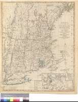
Title: Bowles's New Pocket Map of the Most Inhabited Part of New England, comprehending the Provinces of Massachusets Bay and New Hampshire, with the Colonies of Connecticut and Rhode Island, Divided into their Counties Townships, etc. : together with an Accurate Plan of the Town, Harbour and Environs of Boston
Área de datos: Escala [ca. 1:850000], 6 english marine leagues [= 4'5 cm]
Publication: London : Carrington Bowles, [17--?]
Physical description: 1 mapa : col. ; 64 x 52 cm
Notes: Escala gráfica de "20 english miles" [= 4 cm]. Coordenadas referidas al meridiano de ferro (O 56º30'-O 51º30'/N 44º30'-N 40º30') y al meridiano de Londres. Red geográfica de 30' en 30'. Orientado con lis en cuadrante y círculo
Relieve de perfil
Indica las divisiones administrativas en color verde, rojo, amarillo y azul
Inserta: Plan of Boston with its Harbour and Environs.- Escala [ca. 1:70000], 2 miles [= 4'8 cm]
Materia / lugar / evento: Colonización
Divisiones administrativas
Otros autores: Bowles, Carrington
Títulos secundarios: ESTADOS UNIDOS. NE. Colonias. 1:1850000 (17)
UDC: 912:325.2/.4(73-18)"17"
73-18
Type of publication:
 Maps
Maps
Derechos: