
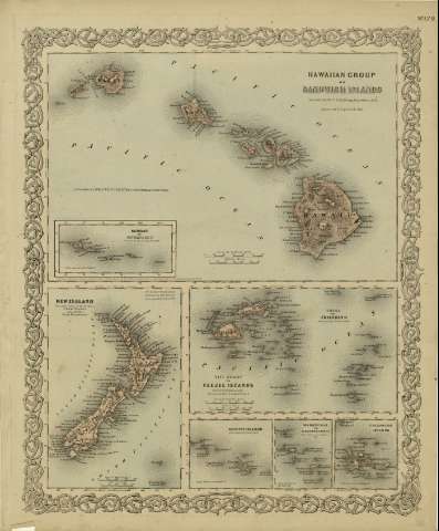
Samoan or Navigators Islands : surveyed by the U.S. Ex....


Sección: Mapas
Título: Samoan or Navigators Islands : surveyed by the U.S. Ex. Ex. 1839 / [drawn by George Woolworth Colton]
Área de datos: Escala [ca. 1:7.315.136], 150 statute miles [= 3,3 cm] (O 173º20'--O 167º20' /S 12º20' -S 15º00')
Publicación: New York : published by G.W. and C.B. Colton & Co., [1872]
Descripción física: 1 mapa ; 5 x 10 cm, en h. de 44 x 36 cm
Notas: Indica meridianos de origen: Washington y Greenwich ; Márgenes graduados.
Inserto en: Hawaiian Group or Sandwich Islands.
Con: New Zealand ; Feejee Islands ; Society Islands ; Marquesas or Washington Islands ; Galapagos Islands.
Inserta nota: "Entered according to Act of Congress in the year 1855 by J.H. Colton & Co. in the Clerk's office of the district court for the southern district of New York".
Registros relacionados: En: Colton's General Atlas : containing one hundred and eighty steel plate maps and plans, on one hundred and nineteen imperial folio sheets. - New York : published by G.W. and C.B. Colton & Co. n 172 William St., [1872]. - Nº 129
Materia / lugar / evento: Mapas físicos
Samoa - Mapas
Otros autores: G.W. & C.B. Colton & Co.
Títulos secundarios: Polinesia. Mapas físicos. 1872. 1:7315136 (1839)
CDU: 912:911.2]:551.42(961.31)'1839'
961.31
Tipo de publicación:
 Mapas
Mapas
Derechos: