
Sketch of the Position of the British Forces at Elizabeth...


Sección: Mapas
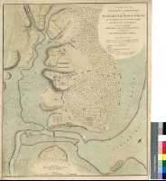
Título: Sketch of the Position of the British Forces at Elizabeth Town Point after their Return form Connecticut Farm, in the Province of East Jersey : under the Command of His Excelly. Leiutt. Genl. Knyphausen, on the 8 th. June 1780 / By John Hills, Lieutt. 23d. Regt. & Asst. Engr
Autor: Hills, John
Área de datos: Escala [ca. 1:5300]
Publicación: London : Published by Willm. Faden, Geographer to the King, Charing Cross, April 12 th. 1784
Descripción física: 1 mapa : col. ; 61 x 52 cm
Notas: Escala gráfica de 1200 pasos [= 15,5 cm]. Orientado con lis
Relieve representado por sombreado
Relación de las principales posiciones de las tropas y baterías que participan en el enfrentamiento bélico, indicadas por clave alfabética
Figura representación esquemática de la vegetación
Procede de la "Colección Mendoza"
Materia / lugar / evento: Guerra
Mapas generales
Tropa
Baterías militares
Vegetación
Nueva Jersey (Estados Unidos)
Otros autores: Faden, William, 1750-1836
Títulos secundarios: ELIZABETH (Estados Unidos) (Nueva Jersey). Operaciones bélicas. 1784. 1:5300 (1780)
CDU: 749 Elizabeth
Tipo de publicación:
 Mapas
Mapas
Derechos: