
A Map of the Pyrenees and the adiacent provinces


Sección: Mapas
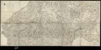
Título: A Map of the Pyrenees and the adiacent provinces / by Roussel and Blottiere ; with Additions from Tofirio and Lopez... ; by his royal Nighnes's... A. Arrowsmith
Área de datos: Escala [ca. 1:220.000]. 5 lienes [= 13,2 cm]
Publicación: London : by A. Arrowsmith 10 Soho Square, 5th. January 1809
Descripción física: 1 mapa en 10 h. : montado sobre tela ; 101 x 214 cm en h. de 50,5 x 42,8 cm o menos
Notas: Escalas gráficas de '15 Geographical miles' [= 13 cm] y '15 english statute miles' [= 11,6 cm]. Orientado con lis
Relieve representado por sombreado
Nota sobre los mapas que han servido de base para la formación de éste
Dedicatoria: To his Royal Highness The Prince of Wales
Nombre jerárquico lugar: España Pirineos
Francia Pirineos
Otros autores: La Blottière, Françoise de, 1673-1739
Tofiño de San Miguel, Vicente, 1732-1795
López, Tomás, 1730-1802
Arrowsmith, Aaron, 1750-1823
Títulos secundarios: PIRINEOS (Cordillera). 1:220.000
CDU: 912:[551.43:341.222](234 Pirineos)'1809'
234 Pirineos
Tipo de publicación:
 Mapas
Mapas
Derechos: