
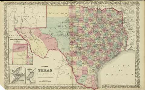
Colton's Texas : compiled from J. de Cordova's large map


Sección: Mapas
Título: Colton's Texas : compiled from J. de Cordova's large map
Área de datos: Escala [ca. 1:2.693.600], 80 miles [5'5 cm] (O 107º--O 92º30' /N 34º--N 26º20')
Publicación: New York : published by G.W. and C.B. Colton & Co., [1872]
Descripción física: 1 mapa : col. ; 36 x 70 cm, pleg. en 36 x 44 cm
Notas: Indica meridianos de origen: Washington y Greenwich ; Márgenes graduados.
Indica divisiones administrativas marcadas por colores.
Inserta: Plan of the northern part or Panhandle of Texas ; Plan of Calveston bay: from the U.S Coast Survey ; Plan of Sabine Lake.
Inserta nota: "Entered according to Act of Congress in the year 1855 by J.H. Colton & Co. in the Clerk's office of the district court for the southern district of New York".
Registros relacionados: En: Colton's General Atlas : containing one hundred and eighty steel plate maps and plans, on one hundred and nineteen imperial folio sheets. - New York : published by G.W. and C.B. Colton & Co. n 172 William St., [1872]. - Nº 55 - 56
Materia / lugar / evento: Mapas políticos
Divisiones administrativas - Mapas
Texas - Mapas
Nombre jerárquico lugar: Estados Unidos - Texas
Otros autores: G.W. & C.B. Colton & Co.
Títulos secundarios: TEXAS (Estados Unidos). 1:2693600
CDU: 912:911.2]:[625.7+625.1](764-2/-5'1872'
764
Tipo de publicación:
 Mapas
Mapas
Derechos: